- Home Page
- Introduction
- Instrumentation
- System & Database
- Networking
- Visualization
- Science
- Demonstrations
- People
- Publications
- Related Projects
-
|
Instrumentation
 REINAS has been designed to accept data from a variety of meteorological and oceanographic instrumentation, but is flexible to accept real-timedata from practically any source. REINAS has been designed to accept data from a variety of meteorological and oceanographic instrumentation, but is flexible to accept real-timedata from practically any source.
Initially, the project focused upon interfacing three specific kinds ofenvironmental instrumentation:
-
Meteorological Stations generate simple time-series streams, typically produced from sensors measuring
- wind speed and direction
- air temperature
- relative humidity, and
- barometric pressure.
In addition, precipitation, solar irradiance, wind gusts, as well as other measurements may be produced.
-
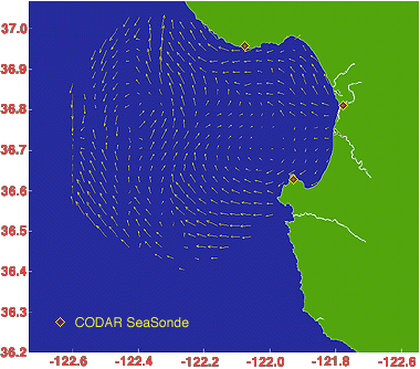
CODAR SeaSondes are compact high-frequency radar systemsthat map the radial components of ocean surface current fields todistances of approximately 70 kilometers.
Radial current fields produced by multiple appropriately placedSeaSondes can be combined to producea two-dimensionalarray of total current vectors such as that depicted in the image below.
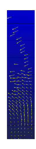
- Wind Profilers generate a vertical profile of the atmosphere,also using radar. By examining radar return echos, the wind speed anddirection at various heights can be determined. Over a prescribed timeinterval (nominally one hour), an array of inferred wind velocities,indexed by height, with typical vertical resolutionsof 250 meters to altitude below seven kilometers (see sample data at left).
In addition to these three core sets of instrumentation, REINAShas since demonstrated it can accomodate measurements from a varietyof other oceanographic and meteorological instrumentation, including:
- Conductivity-Temperature-Depth Sensors or CTDs: submerged sensors measuring basic ocean properties analagous to meteorological stations above the ocean surface;
- Thermistor Chains: submerged vertical chains of sensors, typically suspended from a buoy or ship, generating an array or or vertical profile of ocean temperature readings;
- Rawinsondes: meteorological balloons lofting in-situ sensors into the upper atmosphere while being tracked by ground-based radars in order to infer wind speed and direction along the balloon track;
- Satellite Imagery: geostationary or polar orbiting satellites equipped with sensitive imaging instrumentation of varying spatial resolution;
- Global Positioning Receivers: mobile instruments producing position readings nominally accurate to within 100 m using signals from an array of geostationary satellites managed by the United States Department of Defense;
|